International Connection
There are two modes of international connection for the Underway research data: near-real-time (NRT) connection from aboard the ships during the expedition and a delayed-mode process that allows for in-depth scientific quality control of the data.
Near-real-time
Near-real-time data forms an essential basis for accurate weather and ocean forecasts. Its timely availability enables meteorological services worldwide to keep models up to date, thereby significantly improving the quality of forecasts for weather events and maritime conditions.
Some of the ‘on-the-go’ research data is forwarded to international platforms in NRT mode. This includes, in particular, thermosalinograph data from the research vessels ALKOR, MARIA S. MERIAN, METEOR, POLARSTERN and SONNE. This data is automatically downloaded every 24 hours, processed and then sent by email to a functional address of the GOSUD/CORIOLIS programme at the French marine research institute Ifremer. There, an automated quality control is carried out before the data is forwarded to the Global Telecommunication System (GTS) of the World Meteorological Organisation (WMO). This system then makes the data available to other international data centres, where it is used for weather forecasts and global oceanographic analyses, among other things.
Near-Real-Time-Daten bilden eine essenzielle Grundlage für präzise Wetter- und Ozeanprognosen. Ihr zeitnaher Zugang ermöglicht es meteorologischen Diensten weltweit, Modelle aktuell zu halten und so die Vorhersagequalität für Wetterereignisse und maritime Bedingungen deutlich zu verbessern.
DELAYED-MODE
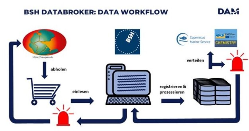
BSH DataBroker
The data published by PANGAEA is transferred to international portals via a DataBroker operated by the BSH. Currently, data is transferred to Copernicus Marine Services and EMODnet-Chemistry for international reuse.
Data sets that have passed through the data flow described above and have been published in PANGAEA without restrictions are identified by automated query routines of the BSH Data Broker. These data sets are then registered in the BSH Data Broker database and converted into the respective standardised formats of the international portals.
During these automated routines, the data undergoes additional internal quality control by the BSH Data Broker. In the event of discrepancies, incorrect data and metadata are tracked and feedback is provided to PANGAEA or directly to the data stewards. The data sets produced then undergo the respective quality controls of the international data portals. If errors occur, feedback is sent to the BSH Data Broker.
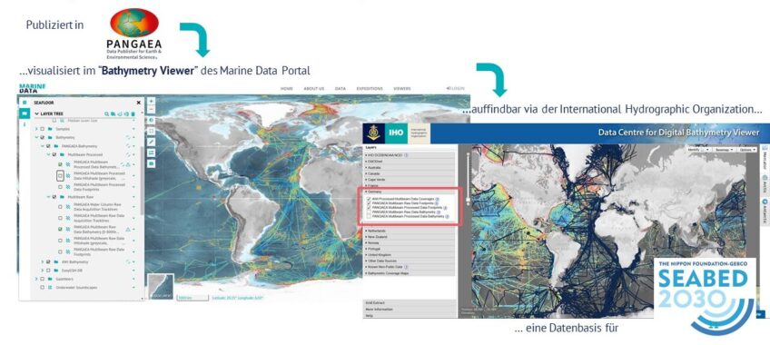
GEBCO
Bathymetry data is made available to the international community directly via the PANGAEA Bathymetry Web Map & Feature Service, independently of the data broker. The web service is integrated, for example, into the viewer of the Data Centre for Digital Bathymetry (DCDB) of the International Hydrographic Organisation (IHO), a globally recognised data portal for bathymetry data (https://www.ncei.noaa.gov/maps/iho_dcdb/). All bathymetry data published in PANGAEA (raw data and processed data) is thus systematically included in the web service and is available for reuse or integration in projects such as the Nippon Foundation-GEBCO Seabed 2030 project.
Our Sponsors
The federal government and the governments of the five northern German states support the current development and sponsor the DAM.